


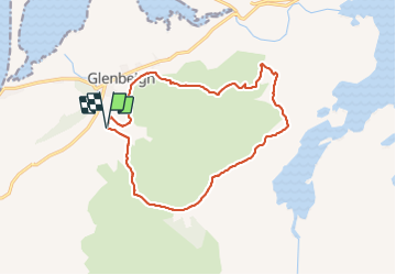
Kerry way Glenbeigh

cl56
User

Length
13.6 km

Max alt
334 m

Uphill gradient
522 m
Km-Effort
21 km

Min alt
61 m

Downhill gradient
524 m
Boucle
Yes
Creation date :
2023-06-06 13:18:15.193
Updated on :
2023-06-07 08:54:32.319
3h50
Difficulty : Medium

FREE GPS app for hiking
 SityTrail
IGN / Geographical institutes
SityTrail Plus
The world is yours!
About
Trail Walking of 13.6 km to be discovered at Unknown, County Kerry, Kenmare Municipal District. This trail is proposed by cl56.
Positioning
Country:
Ireland
Region :
Unknown
Department/Province :
County Kerry
Municipality :
Kenmare Municipal District
Location:
Glanbehy
Start:(Dec)
Start:(UTM)
435285 ; 5766615 (29U) N.
Comments